
La Jonction – Chamonix Hikes
The trek to La Jonction is one of the toughest of the classic day hikes around Chamonix. With around 1500 metres of ascent in seven kilometres, the climb feels relentless. The rewards are some of the best up close views of the Chamonix glaciers. What’s more, you’ll be following in the footsteps of Jacques Balmat and Dr. Paccard as they made the first ascent of Mont-Blanc in 1786. If you take the Bossons charlift, you can reduce these figures a little, but it’s still a big day.
Stats:
Distance: 14km (12km if you use the chairlift)
Height gain/loss: 1520m (1240m if you use the chairlift)
Time: 6-7 hours hiking time
Grading: Physical ![]() Technical
Technical ![]()
Starting point
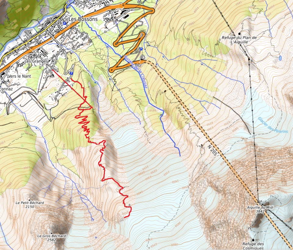
The walk starts by the ski jump (tremplin) in Les Bossons, or you can take the Bossons chairlift from a little lower down the hill. There is parking in both places. If you are using public transport, Chamonix bus number 2 stops by the chairlift. You’ll want the Glacier des Bossons stop.
Taking the chairlift takes you to the Chalet des Glacier des Bossons café at 1500m, saving nearly 300 vertical metres of walking. The chalet itself is a pleasant viewpoint serving drinks, ice creams and local dishes. If you start at the ski jump, follow the path uphill through the woods to the top of the chairlift.
Chalets des Pyramides
Above the chairlift, a good path climbs steeply through the woods, settling into regular zig-zags. After 400 metres of effort, you reach another mountain restaurant, the Chalet des Pyramides at 1900m. This offers views down onto the shrinking Bossons glacier. It’s also the last place to buy sustenance on the route. Above here there is nowhere to top up your water, so make sure you have enough.
If you want to buy anything here, make sure you carry some cash. The chalet is quite remote, with intermittent phone signal, so you won’t be able to use bank cards.
The top section
A couple of hundred metres above the chalet, the trees start to thin out, giving way to scrubby bushes then open hillsides. On a hot day, you might miss the shade of the trees, but there is often a cooler breeze up here. The path follows a broad ridge between the glacial valleys of Bossons and Taconnaz.
Around 2200m there is a short descent to the right before you climb back to cross the ridgeline. This small col between Bec du Corbeau and Mont Corbeau marks the point where the path gets more difficult. The IGN map shows a dotted line, for difficult hiking route, from here to the top. There are narrow and exposed sections interspersed with rocky scrambles. Here the path disappears and you find yourself following the paint marks on the rock.
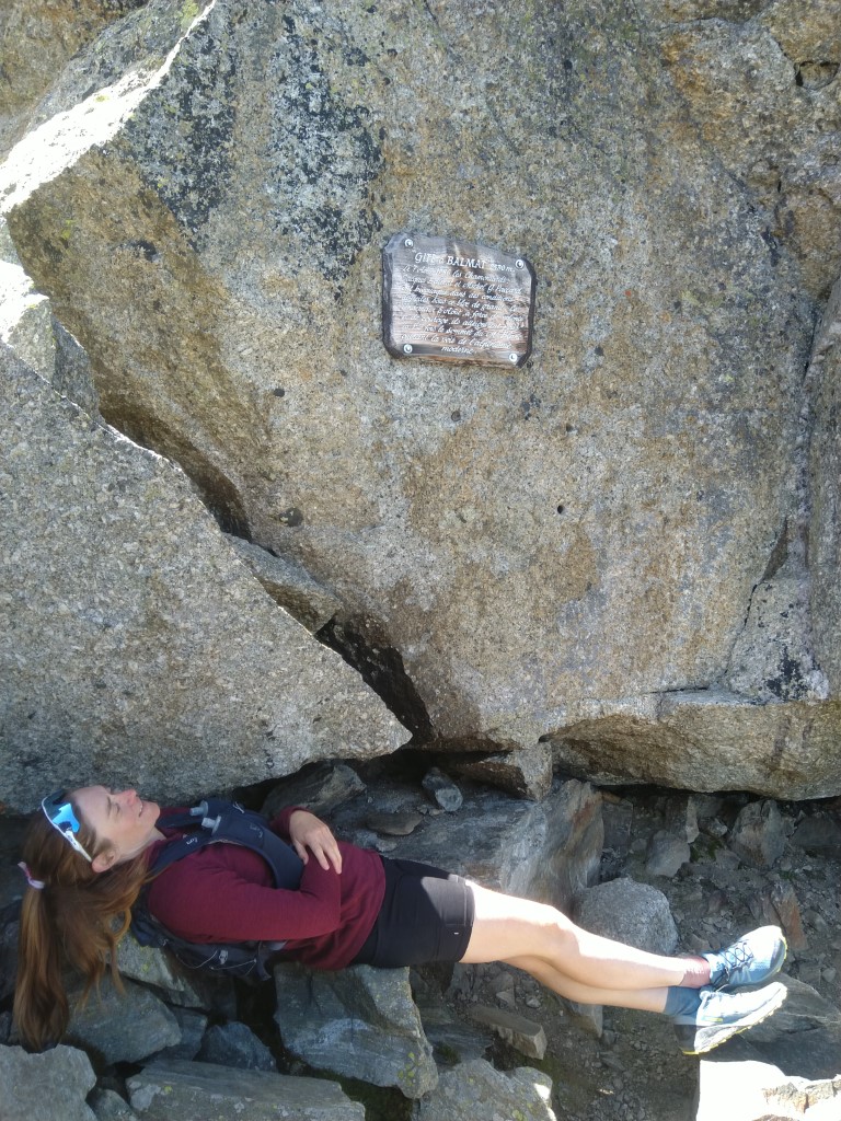
Gîte à Balmat and La Jonction
Marked on the IGN map as an unmanned refuge, this is in fact just a slight cave beneath a boulder where climbers have sheltered over the years. The name is a humorous nod to Jacques Balmat, who slept here with Dr. Paccard on their way up Mont Blanc.
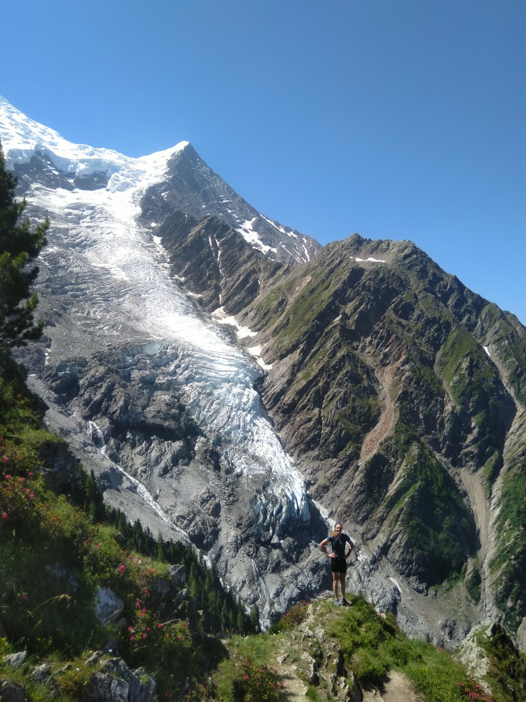
Marked by a plaque on the rock, the “Gîte” is easily missed if you are not looking out for it. Above here, a few more minutes of walking will bring you to La Jonction. Named for the junction of the glaciers, this viewpoint puts you right in the middle of a field of ice and crevasses. It is a remarkable spot, with a high mountain feeling surrounded by ice. Yet you can reach it with no more equipment than a pair of hiking shoes and some spare warm layers.

Descent from La Jonction
The descent is made by the same path – there are few options for a circular route here. The map does show a faint path which winds down below the Taconnaz glacier, but it isn’t recommended. Take care on the steeper sections and don’t try to descend too quickly. It’s well worth stopping at one of the two chalets for a well-earned drink on the way down, now that you don’t have the big climb ahead of you.
Summary
La Jonction is a well-known classic. While popular, it doesn’t get too crowded like some of the easier walks in the valley. The climb is long and increasingly barren, with quite tricky sections near the top. However, the rewards are well worth the effort you’ll put in. Standing at the top on the edge of the glaciers is like being in a different world. If you’re a fit, competent hiker this route is highly recommended. But if you’re new to hiking, we’d suggest tackling some easier routes before this one.
Get in touch if you want more information on Chamonix hiking, or to book a guided trek. Or check out our trekking pages to see all our trekking offers – group or private, guided or self-guided.
We have more Mont-Blanc hiking articles here if you want some more ideas.


